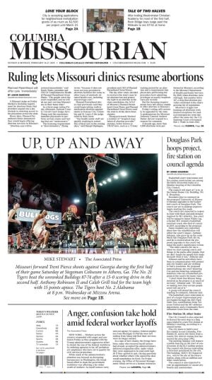


Four Tigers reached double figures scoring, and the visitors took advantage of turnovers Saturday at Stegeman Coliseum.
Four Tigers reached double figures scoring, and the visitors took advantage of turnovers Saturday at Stegeman Coliseum.

The shop serves over 100 customers for the holiday, making it by far their most lucrative day of the year.
The 80-member team departs Sunday afternoon and will focus on water rescue.
The Columbia City Council will meet 7 p.m. Feb. 17.
A judge ruled Friday the state’s abortion clinic licensing requirements were ‘discriminatory.'
Collin Knight stabbed his father more than 15 times in September 2022 at their home between Ashland and Hartsburg.
Also, Columbia's Solid Waste Division plans to combine Monday's regular trash collections with early Tuesday pickups. Read moreColumbia cancels mid-week curbside recycling collection for one week

Columbia and Boone County residents will vote in City Council elections and for two members of the Columbia School Board. Read moreHow the Missourian is covering the April 8 municipal election

Questions and responses from candidates at community forums have been compiled in a grid for easier review by readers. Read moreGrid breaks down Columbia School Board candidates' views on key issues

Questions and responses from mayoral candidates at community forums have been compiled in a grid for easy review by readers. Read moreColumbia mayoral candidates answer questions on key city issues in 2025 election

Questions and responses from candidates at community forums have been compiled in a grid for easier review by readers. Read moreColumbia City Council candidates weigh in on issues, priorities in 2025 election
Previous attempts have failed, but emboldened by federal cuts to programs, Missouri lawmakers have filed anti-DEI leg… Read moreMissouri Republicans continue push to bar state funding of diversity, equity and inclusion
Legal and advocacy experts encourage students, faculty and staff to be aware of the triggers that allow these changes… Read moreExperts discuss impact of recent DEI crackdowns in higher education

Skylark partnered up with Blooms and Wishes Flowers to host the first ever Books and Blooms event on Friday for Valen… Read moreBlooming one page at a time

John Evelev from MU's English Department shares how his literary research gave him a new appreciation for the holiday. Read moreMU professor looks into how America's love for Valentine's Day grew
Columbia and Boone County residents will vote in City Council elections and for two members of the Columbia School Board. Read moreHow the Missourian is covering the April 8 municipal election
Questions and responses from candidates at community forums have been compiled in a grid for easier review by readers. Read moreGrid breaks down Columbia School Board candidates' views on key issues
Questions and responses from mayoral candidates at community forums have been compiled in a grid for easy review by readers. Read moreColumbia mayoral candidates answer questions on key city issues in 2025 election
Questions and responses from candidates at community forums have been compiled in a grid for easier review by readers. Read moreColumbia City Council candidates weigh in on issues, priorities in 2025 election
Skylark partnered up with Blooms and Wishes Flowers to host the first ever Books and Blooms event on Friday for Valen… Read moreBlooming one page at a time
John Evelev from MU's English Department shares how his literary research gave him a new appreciation for the holiday. Read moreMU professor looks into how America's love for Valentine's Day grew
Columbia and Boone County residents will vote in City Council elections and for two members of the Columbia School Board. Read moreHow the Missourian is covering the April 8 municipal election
Questions and responses from candidates at community forums have been compiled in a grid for easier review by readers. Read moreGrid breaks down Columbia School Board candidates' views on key issues

Mizzou baseball suffered a 9-7 loss to Stetson, getting outhit 13-11 in the Puerto Rico Challenge on Sunday in Caguas, Puerto Rico. Read MoreDefense, pitching falter late as Mizzou baseball falls to Stetson

St. Louis has not signed any free agents to major league contracts after missing the playoffs for the second straight… Read MoreArenado reports to camp after Cardinals tried to trade him in offseason

Mizzou women's basketball shot 91% from the field and 75% from deep in the second quarter but fell 82-66 to No. 16 Ok… Read MoreMU's red-hot second quarter unable to soften blow of second-half skid, resulting in loss to No. 16 OU

Shaq's OGs won the first All-Star mini-tournament in NBA history on Sunday night, getting 15 points from Tatum and 12… Read MoreShaq's OGs win the 1st NBA All-Star mini-tournament, topping Chuck's Global Stars 41-25 in the final
Columbia College bowling finished with an overall total of 6,829 to place 51st out of 66 teams. Read MoreCC bowling wraps up play in 56th annual Hoosier Classic

William Byron became the youngest driver to win multiple Daytona 500s, breaking the record held by Jeff Gordon, and H… Read MoreByron avoids late wrecks to win 2nd straight Daytona 500 for Hendrick Motorsports

Tommy Pham, who turns 37 next month, split last season among the Cardinals, White Sox and Royals, hitting .248 with 2… Read MoreFormer Cardinals, Royals outfielder Pham and Pirates finalize 1-year contract for $4,025,000
A showcase of thriving, homegrown businesses around the state of Missouri. Read the stories.
Columbia and Boone County residents will vote in City Council elections and for two members of the Columbia School Board. Read MoreHow the Missourian is covering the April 8 municipal election
The rate of inflation has slowed, but it is still rising faster than economists are comfortable with. Read MoreThe Biden economic hangover
Missouri’s GOP senators are kowtowing to the perceived powers of an unelected and never confirmed head of a make-beli… Read MoreWe must remind politicians of their sworn oath as we watch our democracy fade
One of the most compelling reasons for us to put time, energy and money into alleviating poverty is its impact on children. Read MoreThe hidden costs of local poverty and why Columbia must act
Rural states are facing a health care crisis at a time when health insurance companies are making record profits. Read MoreMU Health Care wants to put patients first. Anthem isn't working toward the same goal.
Every day, there’s news likely to distress anyone who didn’t vote for Trump. But outrage gets us nowhere. Read MorePolitics is learning how to lose better
Foreign aid has long been a potent weapon in America's worldwide battle for allies and influence. Read MoreForeign aid helps America
Subscribers can view cartoonist John Darkow's latest cartoons.