Publications
 Partners


There will be gale force north-westerly to westerly winds (65-80km/h) between Cape Columbine and Cape Agulhas in the early morning, spreading eastwards to Plettenberg Bay by late morning and to Port St Johns in the afternoon as well as the Central Karoo of the Western Cape.
The South African Weather Service also warns of high seas, with wave heights between 6 and 9m expected between Cape Columbine and Port St Johns.
Other warnings
- A storm surge is expected along the coast between Cape Agulhas and East London as well as the False Bay region.
- Heavy rain leading to localised flooding is expected in places in the Cape Metro as well as the mountainous regions of the Cape Winelands and Overberg.
- Disruptive snowfalls leading to temporary closure of mountain passes can be expected in the Cape Winelands District of the Western Cape on Monday evening, spreading to the Little Karoo overnight.
- Extremely high fire danger conditions are expected over the Central Karoo of the Western Cape, the Eastern Cape, eastern parts of the Northern Cape, the western parts of both the North West and Free State as well as the north-western parts of KwaZulu-Natal.
Special weather advisories
- Light snowfalls are expected over the western high ground of the Western Cape from Monday late afternoon, spreading to the eastern high ground of the Western Cape and the southern high ground of the Northern Cape by evening, and to the high ground of the Eastern Cape overnight into Tuesday morning.
- Strong interior winds of 50 to 65km/h are expected over the interior of the Western Cape, southern interior of the Northern Cape, southern parts of the Free State, and the interior of the Eastern Cape.
- Very cold conditions are expected over the interior of the Western Cape, southern interior of the Northern Cape, northern interior of the Eastern Cape and southern parts of the Free State on Tuesday.
- Frost is expected over the northern interior of the Eastern Cape, the Free State and the southern and eastern parts of the Northern Cape on Wednesday morning.
The weather in your province
Gauteng will be fine, windy and cool.
The expected UVB sunburn index is high.
It will be fine, windy and cool in Mpumalanga, but warm to hot in the Lowveld.
Limpopo will be fine and warm.
Fine, windy and cool to warm conditions can be expected in the North West.
In the Free State it will be fine, windy and cool.
It will be cloudy, windy and cold to cool in the Northern Cape, with isolated showers and rain in the west and south, but scattered in the extreme south-west.
It will be fine and cool in the east, where it will become partly cloudy from afternoon.
Light to moderate snow can be expected over the southern high ground from the evening, where it will be very cold.
The wind along the coast will be light to moderate north-westerly, becoming fresh south-westerly in the afternoon.
The Western Cape will be cloudy and cold to cool, with scattered showers and rain in the west, spreading to the east from late morning, but widespread in the south-west.
Light snow can be expected over the western high ground in the afternoon, spreading to the eastern high ground in the evening.
It will be very windy.
The wind along the coast will be strong to gale north-westerly south of Cape Columbine, becoming strong to gale westerly to south-westerly in the afternoon, otherwise light to moderate north-westerly, becoming fresh to strong south-westerly in the afternoon.
The expected UVB sunburn index is low.
The western part of the Eastern Cape will be fine, cool and windy, becoming cloudy from the south-west, with isolated showers and rain spreading eastwards, but scattered along the coast.
Snowfall is expected in the evening and overnight on the mountains.
The wind along the coast will be strong to gale force westerly to south-westerly.
Fine, warm and windy conditions can be expected in the eastern part.
It will become cloudy from the west in the evening, with isolated showers, spreading to the Lesotho border overnight.
Light evening snowfall is expected over the northern mountains.
The wind along the coast will be moderate north-westerly, becoming strong south-westerly, but gale force late in the day west of Kei River.
KwaZulu-Natal will be fine and warm, but cool on the western high ground.
The wind along the coast will be moderate north-easterly, becoming moderate to fresh south-westerly in the evening from the south.
The expected UVB sunburn index is high.
- Compiled by Maxine Becket
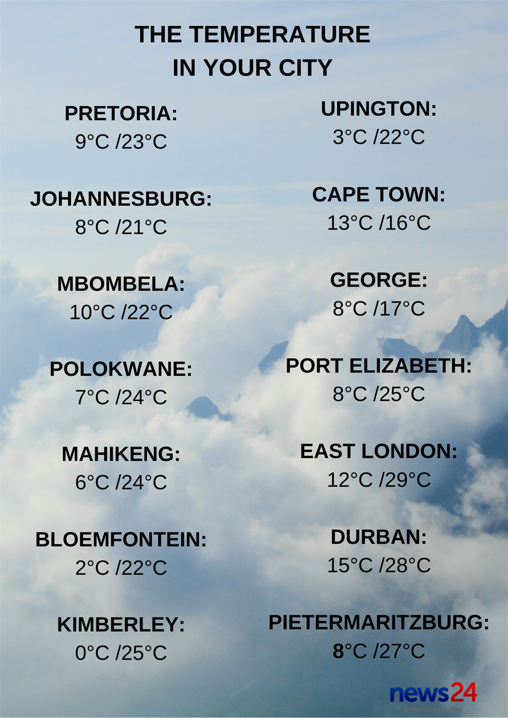
Click here to see the specific forecast for your city over the next few days