Updated 4/17/24 at 9:30 p.m. AST
VI SOURCE WEATHER UPDATES
! A NEW Daily Weather Update video for Thursday, April 18, is available here!
Article: Colorado State University Predicts Extremely Active 2024 Atlantic Hurricane Season
Article: La Niña Weather Pattern May Spawn an Active 2024 Atlantic Hurricane Season
Series: “Extreme Weather in the Caribbean”
- Part 1: Caribbean Earthquakes and Tsunamis
- Part 2: Caribbean Volcanoes
- Part 3: Rip Currents
- Part 4: Hurricanes
- Part 5: Wildfires
- Part 6: Flash Floods
- An article about earthquakes in the Caribbean is available here!
- An informational video about drought conditions in the USVI is available here!
THURSDAY’S WEATHER FORECAST: 4/18/24
Happy Thursday!
According to the National Weather Service (NWS) in San Juan, Puerto Rico, Thursday will be mostly sunny with scattered showers. The high temperature will be approximately 83°F, 28.3°C, with winds out of the north-northeast at about 7 mph. The possibility of rain on Thursday is approximately 30%. Conditions may still be favorable for some heavy rain to develop across portions of the islands. However, overall, conditions will begin to improve.
Thursday night will be partly-to-mostly cloudy, with a chance of scattered showers. The low temperature will be approximately 77°F, 25°C, and winds out of the northeast at about 6 to 9 mph. The possibility of rain on Thursday night is approximately 70%.
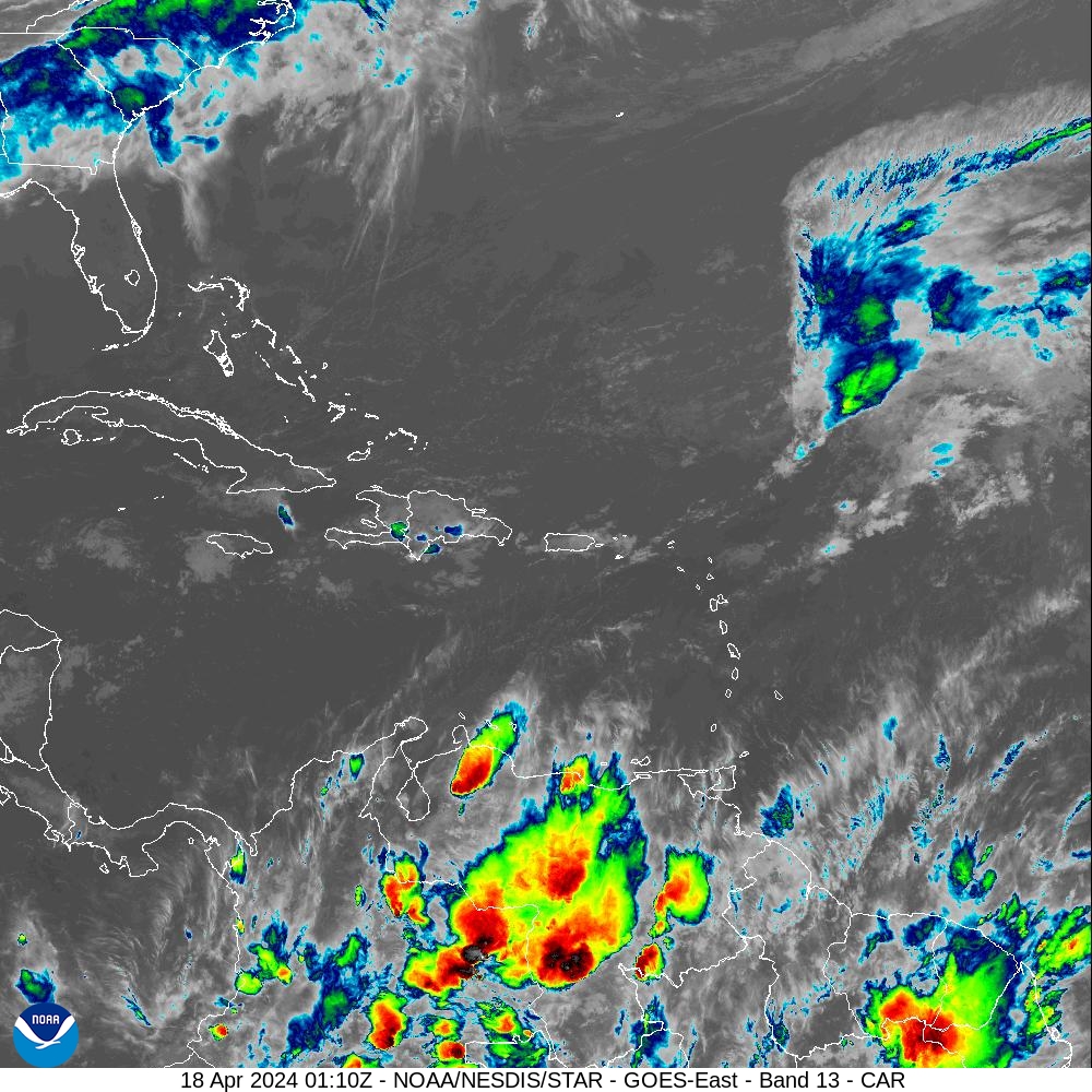
Below: Infrared satellite imagery obtained at 9:10 p.m. AST on Wednesday indicates a partly-to-mostly cloudy sky around the USVI and Puerto Rico. Precipitation is possible.
MARINE WEATHER UPDATE
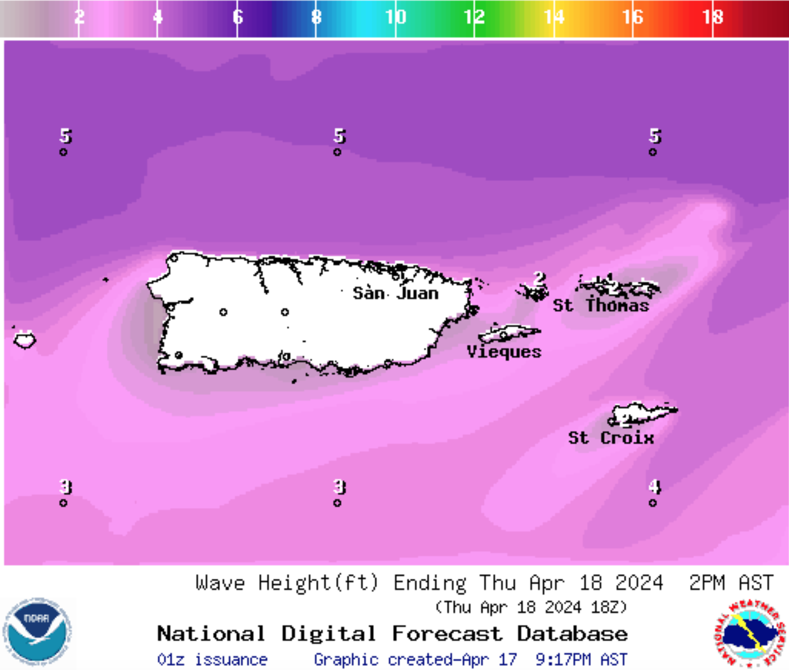
The NWS has noted that a northeasterly swell is expected to arrive around Thursday. According to forecast information, the swell does not appear to be very significant. However, updates will be posted as they become available.
On Thursday, seas will be approximately 2 to 4 feet, occasional seas up to 5 feet, and with a swell period of 11 seconds. Winds will be out of the north-northeast at about 5 to 10 knots.
On Thursday night, seas will be approximately 2 to 4 feet, occasional seas up to 5 feet, and with a swell period of 11 seconds. Winds will be out of the northeast at about 5 to 10 knots.
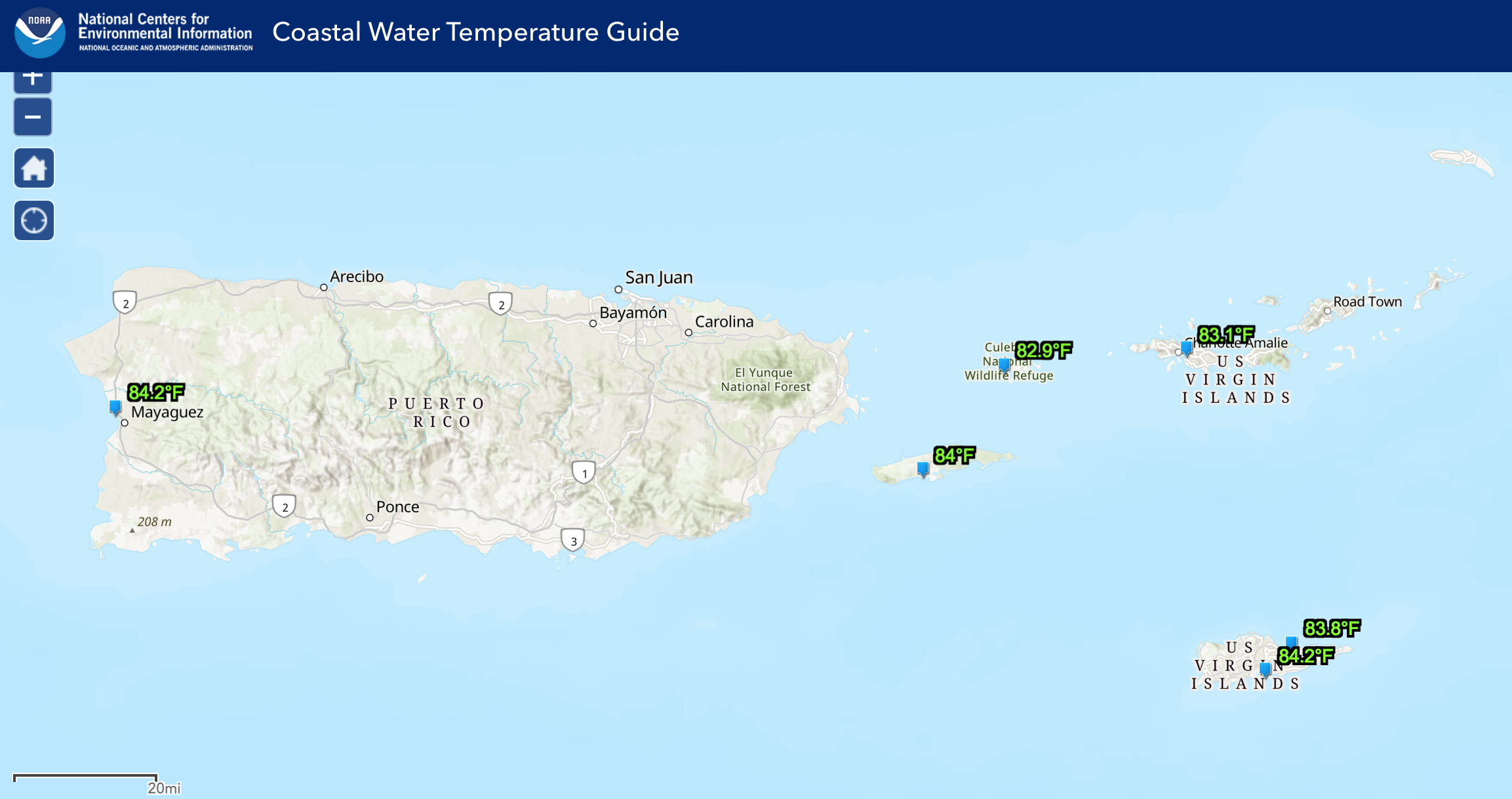
The water temperature is approximately 83-84°F, approximately 28°C.
Ocean Water Temperature Map from 4/16/24, courtesy of NOAA:
Wave Height Forecast Map courtesy of NWS:
HAZARDOUS CONDITIONS
Rip Currents: The risk of rip currents is projected to be moderate across most of the region on Thursday.
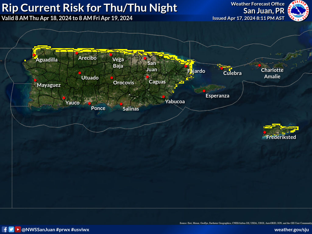
Clear = Low Rip Current Risk
Yellow = Moderate Rip Current Risk
Red = High Rip Current Risk
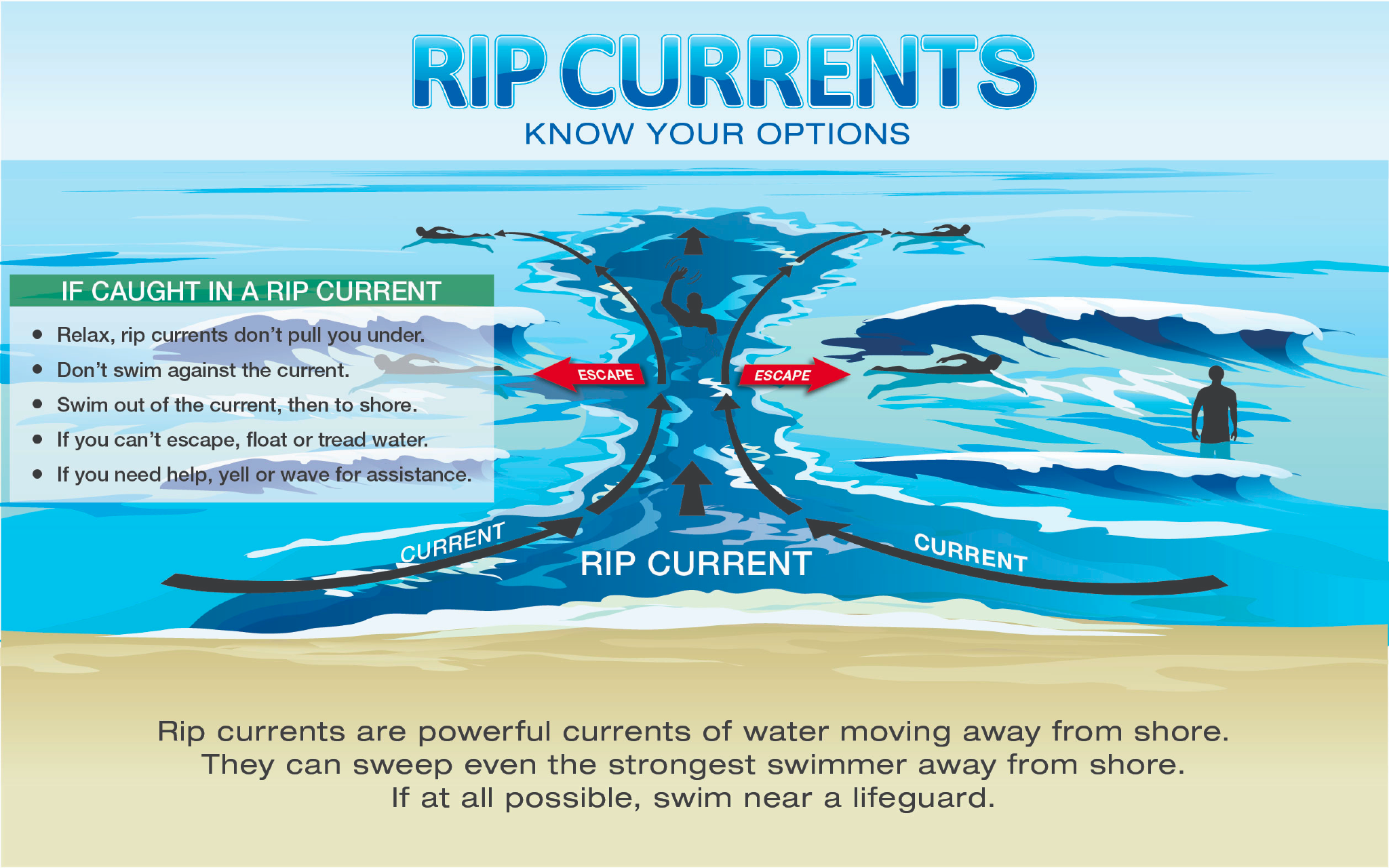
Learn more about rip current safety in an interview between the NWS and the VI Source here.
TROPIC WATCH
Tropical Activity: The National Hurricane Center does not expect any cyclonic development. However, a possible La Niña Weather Pattern May Spawn an Active 2024 Atlantic Hurricane Season. Read more here.
Additionally, Colorado State University Predicts Extremely Active 2024 Atlantic Hurricane Season.
Click here to learn tips on being prepared for the 2024 Atlantic Hurricane Season.
Days Until 2024 Atlantic Hurricane Season: 44 Days
OBSERVATIONS
Sunrise: 6:02 a.m.
Sunset: 6:38 p.m.
Ocean water temperature: Approximately 83-84°F, approximately 28°C.
UV index: 10 out of 10 (VERY HIGH)
Wednesday’s high temperature: 85°F, 29.4°C
Wednesday’s low temperature: 78°F, 25.5°C
Preparation for extreme weather events in the Caribbean, such as earthquakes and tropical cyclones, is important. Residents and visitors in the USVI are encouraged to stay updated on weather events on the V.I. Source Weather page and sign up for alerts from the National Weather Service and the Virgin Islands Territorial Emergency Management Agency.


